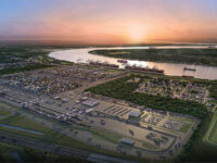
The Port of Buenos Aires

Over a year ago, the Administración General de Puertos (General Port Administration — AGP) was given the task to manage the Vía Navegable Troncal (Mainline Navigable Waterway — VNT), the most important infrastructure project for Argentine foreign trade. After more than 25 years under private concession, the President of the Republic of Argentina and the Minister of Transportation decided to assign us the responsibility of managing the VNT.
The Vía Navegable Troncal is part of the Integrated Navigation System that originates in Mato Grosso, Brazil, and then runs through Bolivia, Paraguay, Uruguay, and Argentina — in fact, connecting seven provinces in the latter. Precisely those features underscore the relevance of this navigable waterway, which moves 80% of Argentina’s foreign trade, and explain the magnitude of the challenge brought about by its maintenance.
After such a long-lived concession, our responsibility for managing the VNT kicked off during what is considered the most significant river drop since the late 19th century. Nevertheless, we were able to ensure navigation and the logistics for foreign trade thanks to the continuous dredging, beaconing and hydrometric monitoring of the waterway.

Simultaneously, we brought transparency to the forefront and published monthly management reports containing statistics on vessel traffic, dredging, hydrological control, beaconing, bathymetry, billing, finance, investments, agreements, and contracts. Not readily available in the past, AGP has made this information public to all users and entities that may want to examine it.
Over several months of this process, appropriate working conditions were kept and all waterway stakeholders were able to see that the state can play a leading role in a responsible and professional manner. It goes without saying that this was a period of learning and adaptation, both in-house and in the work methods themselves, considering the needs of the waterway and of the entire system.
Once navigation was secured, AGP set out to generate value added for the VNT. Although this is a “maintenance” contract, AGP is working to incorporate new tools, within the limits of the agreement.
Firstly, we set up a Waterway Monitoring and Management System, known as SiMon, bringing new technology into the area. Five remote monitoring points (RMPs) were built in strategic sections of the VNT (Braga, Zárate, Rosario, San Lorenzo, and Bella Vista), and a monitoring center (two more coming soon) will integrate data processing, help streamline traffic, heighten security, and protect environmental conditions.
The RMPs will be equipped with automatic identification systems (AIS) to determine the identification, direction, and speed (among others) of vessels moving over the canal. There will also be radars, dual spectrum cameras, and weather stations.
Additionally, each point has smart multiparametric buoys focused on the environmental protection of the waterway. These allow monitoring and processing data in real time — wind, currents, visibility, etc., thus becoming an early warning system that is triggered when readings exceed normal operating values.
With millions invested, implementation of the monitoring system is a milestone in the management history of the VNT, modernizing infrastructure that was previously void of any technology. Moreover, this is a scalable model, meaning that other technological tools may be added gradually to optimize its functioning for navigation.
Once having secured navigation and appropriate conditions to modernize the waterway with state-of-the-art technology, we sat down to plan for the future and discuss the type of system we wanted. This included a strategic vision, expanding the scope of the concession, to cover from Confluencia (km 1238 A) to deep waters (km 239.1 D).
The first step was to broaden management north of Confluencia, up the Paraguay River and the Upper Paraná. This meant expanding the hydrometric network to improve the quality of navigation and information available, considering the chart as part of an integrated system. Hydrometers were set up along the Paraguay River in Las Palmas, Formosa, Bouvier and Pilcomayo, and along the Upper Paraná in Itatí, Ita-Ibaté, Ituzangó, Posadas, Santa Ana, Puerto Maní, Libertador, El Dorado Puerto Libertad and Puerto Iguazú.

To ensure funding for infrastructure and other works, the Ministry of Transportation ordered the establishment of a toll system along the VNT, between the Port of Santa Fe and Confluencia. The new tariff scheme will allow setting up an efficient signage and dredging system in that stretch, giving it a more centralized role than it had under the previous administration, in favor of the federal development of river ports.
In the Paraná Guazú area, we are examining how to boost its utilization since, due to natural conditions, the channel can take larger vessels along easier-to-navigate routes, and provides a safer connection to the channels of Martín García or Buenos Aires.
Lastly, we are in the phase of developing one of the most important strategic projects for the logistics of an integrated system like this one: the Canal Magdalena. In July 2021, the last environmental permits were approved. In 2022 we worked with the Navy Hydrography Service to sign and execute a bathymetric survey along the Canal Magdalena. Measurements were taken every 50 meters, analyzed in detail, and complemented with data gathered in 2014. Once operational, the entire Argentine port system will be integrated, connecting the river ports along the VNT with the seaports along the Atlantic Ocean coast. This will also boost the development of related services in the Province of Buenos Aires and will significantly reduce navigation time and, consequently, related costs.